

☀️ ADRIATIC COAST · Central Dalmatia · 🏝️ Brač Island · Selca (Brač)
Puntinak
Loading verdict…
Aligning wind direction, wave height, and coastal relief.
BEACH GUIDE & OVERVIEW · LOCATION & ESSENTIALS
About Puntinak, Selca
Beach Puntinak is located in Selca (Central Dalmatia). Official IZOR water quality: Excellent.
Puntinak · Selca
Interactive map loads as you scroll…
128° · SE (Sirocco)
The cove faces open sea at an angle of 128°, direction SE (Sirocco); wind shelter is calculated relative to this orientation.
Rocky · Pebble
Seabed slope: Moderate slope (15–25°); natural shade: Low shrubs & pine trees; access: Coastal promenade.
Excellent
Latest official water test (2026-09-21 12:20:00): rating "Excellent", sea temperature 24.1 °C.
3 amenities recorded
Recorded amenities on location: Restaurant, Waste bins / Trash cans, Showers.
📋 Field Characteristics & Accessibility
Field data🌬️ Geomorphological Wind Shelter Matrix (128° Bearing)
4-Wind Analysis| Adriatic Wind | Cove Shelter Status | Recommendation & Backup Cove |
|---|---|---|
|
Bora / Bura (NE, 45°)
Gusty katabatic wind from the mainland
|
🟡 Cross-shore | 🛡️ Sheltered backup: Porat (826 m) → |
|
Jugo / Sirocco (SE, 135°)
Warm SE wind bringing long sea swells
|
🔴 Exposed (Waves) | 🛡️ Sheltered backup: Hotel Galeb (6.9 km) → |
|
Maestral (NW, 315°)
Refreshing afternoon summer thermal breeze
|
🟢 Sheltered (Calm) | Calm swimming directly in this cove |
|
Lebić / Garbin (SW, 225°)
Southwesterly swell and coastal surf
|
🟡 Cross-shore | Seek opposite leeward shore in strong gusts |
Puntinak is a coastal beach and bay situated in Selca (Central Dalmatia). According to official microbiological monitoring by the Institute of Oceanography and Fisheries (IZOR), the sea water quality here is rated as Excellent.
The cove faces open sea at an angle of 128°, direction SE (Sirocco); wind shelter is calculated relative to this orientation. Recorded amenities on location: Restaurant, Waste bins / Trash cans, Showers.
Latest official water test (2026-09-21 12:20:00): rating "Excellent", sea temperature 24.1 °C.
METEO & MARINE GUIDE · OPEN-METEO MARINE & DHMZ
Sea conditions, wind and wind shelter
Fetching meteorological and oceanographic models for coordinates 43.27983, 16.86268…
Click an hour to see expected wind and waves today
Multi-day wind shelter forecast at 14:00 for Puntinak
Loading wind shelter assessment…
Checking wave models, wind speed, and direction relative to coastal relief.
IZOR FIELD PROFILE · INSTITUTE OF OCEANOGRAPHY AND FISHERIES
Beach profile and seabed characteristics
Verified field data from the Institute of Oceanography and Fisheries (Split).
Beach terrain type
Predominantly Rocky, Pebble.
Natural shade
Low shrubs & pine trees
Water entry & depth
Seabed slope: Moderate slope (15–25°).
Access, parking & crowds
Access: Coastal promenade · Parking: No parking · Crowd: High crowd
OFFICIAL PHOTO DOCUMENTATION · UNFILTERED
Authentic field photos of the bay
Showing 3 official field photos taken by IZOR inspectors.
 📷 Main panorama
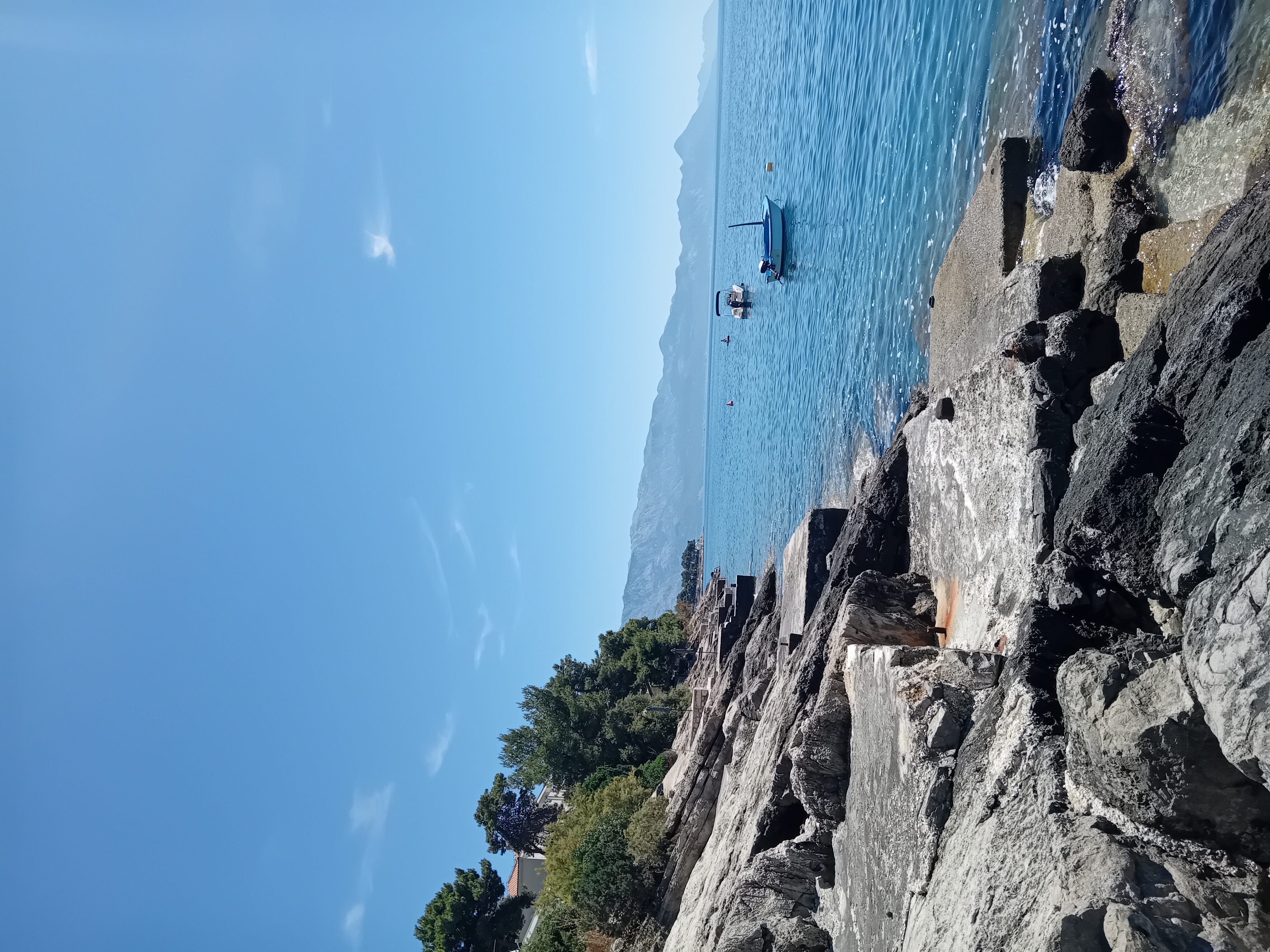 Photo 2
 Photo 3
MICROBIOLOGICAL WATER QUALITY · EU DIRECTIVE 2006/7/EC & REGULATION NN 73/08
Laboratory water quality monitoring
Recorded seasonal laboratory tests (10 cycles) — Rating: Excellent.
BAY AMENITIES · INFRASTRUCTURE & FACILITIES
Amenities and facilities on site
Amenities recorded in official beach profile.
Exact count of recorded items on site:
Accommodation near Puntinak
Search apartments, holiday homes and hotels in Selca within 5 km of this bay.
Boat tours and activities at Puntinak
Book boat rentals, full-day boat tours, snorkeling, kayaking, and SUP excursions in Selca and nearby bays.
Frequently Asked Questions About Puntinak
Key facts about sea water quality, seabed terrain, wind shelter, and access for Puntinak (Selca).
What is the sea water quality rating at Puntinak beach in Selca? ▾
According to official microbiological monitoring by the Institute of Oceanography and Fisheries (IZOR, sampling station #2109), the bathing water quality at Puntinak is rated "Excellent" based on 40 seasonal water samples under EU Bathing Water Directive 2006/7/EC. During the latest official field test (2026-09-21 12:20:00), the measured sea temperature was 24.1 °C.
Which winds is Puntinak bay sheltered from (Bora, Sirocco, Maestral)? ▾
Puntinak faces the open sea at a bearing of 128° (SE (Sirocco)). Based on its coastal relief and backing terrain, the cove provides natural wind shelter from Maestral (NW), while winds blowing directly from SE (Sirocco) can create onshore waves.
What is the beach surface, water entry, and natural shade like at Puntinak? ▾
According to the verified IZOR field profile, the shore and seabed surface at Puntinak consists of: Rocky, Pebble. The seabed entry slope is Moderate slope (15–25°), and natural shade / coastal vegetation is recorded as: Low shrubs & pine trees. The swimming zone is approximately 160 m long.
What facilities, amenities, and parking are available at Puntinak? ▾
Recorded facilities on site include: Restaurant, Waste bins / Trash cans, Showers. Coastal access: Coastal promenade; parking availability: No parking.
Where is Puntinak located and what beaches are nearby? ▾
Puntinak is located in Selca (Brač Island), Central Dalmatia, Croatia at GPS coordinates 43.27983° N, 16.86268° E. The closest officially monitored beaches nearby include: Porat (826 m), Škver (855 m), Hotel Galeb (6.9 km).
NEIGHBORING COVES · OFFICIAL IZOR MONITORING
Nearby Beaches
Other officially monitored beaches and coves near Puntinak. Distances are straight-line measurements.